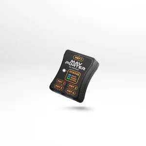

Description
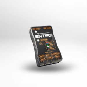
Entire is the best drone accessory you have ever seen.
We are now coming with HW revision 2 with enhanced Multiport LANC control for Sony cameras.
When used as a camera remote, it can be assigned as an extension for AIR Commander Link, or as a standalone solution with SBUS input.
The Entire itself can be controlled by AIR Commander Link, by SBUS or MAV Link telemetry. The Entire is able to control almost all cameras on the market, simple and user-friendly way. It also provides an incredibly simple geotagging solution, your GPS / RTK coordinates go directly into JPG/RAW photos in the camera SD card. Compatible with AIR Commander Link, just map button functions and your remote is ready to go.
- Sony *
- Nikon **
- Canon
- Panasonic GH & S
- FujiFilm (GFX50R/50R/GFX100)
- Z-CAM
- BlackMagic (BMPCC4k/6k, URSA Mini Pro)
- Sony Venice
- RED
- PhaseOne Industrial (with iX Link terminal)
- PhaseOne IQ digital backs
- Marshall (all cameras with RS485 terminal)
*RX1RM1, RX1M1, RX100 are not supported.
*MENU and navigation is available only for cameras with IR sensor (A6*, A7*, A9*).
**For the Nikon D850 shutterspeed is only available in range of 1/30 – 1/8000. ISO, Aperture and other are fully configurable.
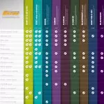
Our road map plans to add much more cameras during this year. Stay tuned!
Geotagging for DJI M600 or PixHawk & Sony cameras:
Entire supports writing of GPS / RTK and Gimbal angles* information from your flight controller (A3/N3/PixHawk) controller directly to the EXIF of photos in the camera SD card. Alternatively can be GPS data stored to the microSD card inserted in the SD slot of Entire. When PixHawk is connected, you can easily trigger photographs via MAVlink from your RC controller or mission event. If the DJI flight controller is used, you can use Fport shutter for triggering camera in mission or manual flight.
*gimbal angles are available only for DJI flight controllers used with DJI gimbal or Gremsy v2/v3 series gimbals and also for PixHawk drones with Gremsy v2 or v3 gimbals.
EXIF is written with an extremely high accuracy of 0.00000001 degrees, which is approx. 1mm accuracy in the distance. Altitude is saved with 0.1mm accuracy. Gimbal angles (Roll/Pitch/Yaw) are available only when DJI gimbal is used.
The camera must support “Mass Storage” USB connection for direct EXIF upload of GPS (or RTK) data. Currently, all Sony cameras support the “Mass Storage” mode.
Geotagging process:
In the moment of takeoff, the Entire is opening the camera via USB and gets the latest file number. During the flight is Entire capturing each photo with GPS coordinates. In the moment of landing will Entire opens the Camera again and upload all metadata right to the EXIF of each photo (JPG or ARW). Our method is very fast and usually takes only a few seconds, for example geotagging of 100 photos taken during the flight takes less than 8 seconds (RAW or JPG).
More information about geotagging